Follow Our Blog!

Saturday, June 11, 2016

Saturday June 11: Back to New York

     Dan gets husband of the year award - this morning he let me sleep in.  He got up at five and I put on my noise canceling headphones.  He weighed anchor, made breakfast, and set off and I slept in till seven-thirty.
     The plan was to get as far as Old Saybrook Harbor and get all tucked in before the forecasted rain and possible thunderstorms spread over Long Island Sound.  The water was glassy and the winds were light, but the horizon was gray all around, and as we traveled we could see the storm clouds darkening.  About mid-morning Dan suggested we head for the tip of Long Island instead of Old Saybrook.  We’d never been to any anchorage on Long Island, and this would be closer to Block Island, where we hope to spend the next couple of nights.  He found a marina on Navionics and called to inquire about a slip.  Yes, they said, they would have room.
     Just before we got to Orient Point - the end of Long Island before Plum Island and Montauk - the rains came.  And the tide turned.  This area was already listed as a “rip tide area”, so we were prepared for a little rough water, and we were very grateful that we only have about thirty minutes of it all before turning into the small and very narrow channel that led to the even narrower entrance of the marina.
Orient Point Light
Plum Island - rumor has it the government tests anthrax here.  Whatever goes on, the whole island is government owned and visitors are prohibited.
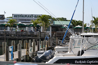
     Orient Point is a very small town that sports a state park and this marina and restaurant.  It’s really more of a marina for fishing charters, (i.e., not fancy, and without much in the way of amenities) but they happily accept transient cruisers and the people here are exceptionally friendly.  We spent a little time at the outdoor bar, meeting Willy from across the Sound who had come over with his buddies for an afternoon of drinking, and watched the local fishing charters filet their catch off the sterns of their boats. The bartender handed over keys to the showers and gave us the wifi code.  Bob, the owner, lent us his truck to go to the next town - eight miles away - for a small grocery run.  After our run, we went back to the restaurant for dinner, and the accommodating staff allowed us to order from the smaller lunch menu because we just weren’t hungry enough for the gourmet dinner entrees.  (Although, we did find room for the peanut butter pie, which was as excellent as the rest of the meal.) What this place lacks in yacht club-type ambience, it makes up twofold in character, friendliness, and food.  
The entrance to the marina - about forty feet wide.
Orient Point Marina & Restaurant.  


Thursday-Friday June 9 & 10: To & Thru New York
     We left the Glimmer Glass in time for the first bridge opening - 7:00 am - without mishap.  It was a little windy, but we hugged the Jersey shore for the 26 miles to Sandy Hook point and though we had a following sea, it was a tolerable ride along the coast  
We passed this pair of egrets on our way out of the Glimmer Glass.
Jersey Shore.

     It was a different story when we got around Sandy Hook.  The sea was confused - wind and current driven, with a five foot chop.  Dan adds “sloppy”, but points out that we only dipped the bow once.  The splashes from the waves drove us indoors; later we found the entire boat coated with salt.
     We had been going back and forth about destinations - tossing around Great Kills Harbor on Staten Island, where we’d stayed in the fall, Coney Creek on Coney Island, or Liberty Park right in New York Harbor.  Great Kills Harbor was closest, Coney Creek didn’t seem prudent given the forecast of Westerly winds, and Liberty Park offered the best all around protection but was about two hours away.
     We opted for Great Kills Harbor.  It was a very bumpy and wet ride, and we were very happy to drop the hook amongst the unoccupied moorings off the Great Kills Yacht Club.  Dan turned in for a nap, I busied myself with small chores.  We had baked zucchini for supper.  It was a very relaxing evening, welcome after the stressful passaged from the tip of New Jersey.
     Friday we were up and out of there, again off by seven.  It had calmed down considerably during the night and we were hoping to ride the current and favorable tide through the Verrazano Narrows and right through New York City.  The seas were much more comfortable as we made our way toward the city.

     As we’ve seen before, this is a very busy harbor!   Ships were anchored in a long row from the bridge to the entrance of the Hudson river, ferries were criss-crossing the area, and there was a steady stream of traffic coming and going around Staten Island.  Even the helicopters were already out and about.  We timed it all pretty well - we traveled through the East river at up to nine knots.  We were through Hell’s Gate by ten-thirty, well before the tide was supposed to turn.
Some of the ships steaming out of the Staten Island inlet.
Anchored ships in front of the city.
Leaving the city behind us.


     We hugged the NY shore as we headed into Long Island Sound.  The current was favorable, but the winds were starting to pick up again.  It was calmer along the shore.  Fortunately, when the current started to shift, the winds died out.  We made it to Norwalk CT for our anchorage, finding a pretty little spot in the Sheffield Islands.  It was near dead calm, which was a good thing, because the anchor bounced along a couple of times before settling down.  (We found out in the morning it had never dug in - note to self: this is an anchorage in calm weather only!)  Spaghetti for supper.  The perfect meal after a chilly day; today we brought out the hats, mittens, and long pants.

Wednesday, June 8, 2016

Wednesday June 8: Manisquan Inlet and the Glimmer Glass

     We set off about eight this morning, intending to get all the way through the rest of the New Jersey Intracoastal Waterway.  This doesn't mean we're done with New Jersey - we still have about 25 miles offshore to cover to get to Sandy Hook - but this is as far as we can go inland.
     It's chilly!  For the first time since early December we are wearing sweatshirts and fleece and wondering where our mittens and warm hats are.
     The skies started clouding over about noon, and shortly thereafter the rain and wind drove us indoors.  The waves really started to kick up, but the tides and currents were with us and we wanted to take advantage, so we pressed on.
In shallow water, it doesn't take much for the waves to pile up.
     We made good time, reaching the Pleasant Point Canal about three pm.  By then the rains had moved through and the sun was out, but it was still windy and quite chilly.  I suppose it's time for us to get used to it.  
Pleasant Point canal.
     We selected as our anchorage a place called the Glimmer Glass.  This is a small basin up a small creek just inside the Manisquan Inlet.  We've heard about it from other cruisers: it's a favorite stopover when they travel up or down the coast of New Jersey.  There is one last bridge to go through before the basin, and this was the only one we encountered today that had a schedule.  It opens on the hour and half hour, and we arrived twenty-five minutes early, plenty of time to watch the whole opening operation.  It's a small bridge, lifted by a cable which is hand operated by the bridge tender.
With a strong current and a strong wind, its narrow opening is something of an adventure.  Not for the faint of heart.
Glimmer Glass bridge tender - Dan thought he looked like Vince Wilfork.
We are heading for the bridge.
     Once through the bridge you are in the anchorage basin.  There is almost no water to port, and a row of docks to starboard.  We drove our keel into the mud yet again (New Jersey will be forever known in our memories for going aground) but this time Dan managed to back out.  Undaunted, he continued farther into the basin where we anchored in about four and a half feet of water midway between the shoal and the docks.  Fortunately we are the only boat anchored here tonight!  
     The wind continues to howl.  We are considering turning on the heater!


Sunday-Tuesday June 5-7:  Out of the Chesapeake and into New Jersey

     We left Rock Hall very early Sunday morning.  We’d had a great meal with Denny and Laura at Waterman’s Restaurant, and afterward ice cream from The Scoop.  Such a treat all the way around.  It was sad to say goodbye.
     Those thunderstorms that had been predicted still hadn’t materialized, but today the air was heavy and the skies were very gray.  We wanted to get to the mouth of the Chesapeake & Delaware canal before anything hit so we left around seven for the quiet run up the Bay.
     Dan’s friend & fellow tug captain Joe sent us a message saying his tug was en route from Philadelphia to Richmond, and currently was entering the C & D canal.  We were ready with the camera when it appeared on our horizon.  Dan called on the radio, but Joe was off watch then, and probably sleeping.  
Joe's tug & barge.

     We dropped the hook in the Bohemia River, which is off the Elk River, which leads to the entrance to the C & D canal.  The thunderstorms were gathering in force in the West.  Joe texted us to tell us the tug had diverted to Baltimore to ride out the weather, and that it was raining quite heavily.  Warnings were broadcasted every fifteen minutes on the radio.  We were ready when it hit, about six in the evening.  It was a quick squall, with only one peel of thunder and perhaps an hour of rain and lots of wind, and then it was done and gone.  We barely collected more than a small jug of water.  
     Monday we again left early as the tide was most favorable to us in the canal then and would be again favorable in Delaware Bay in mid afternoon.  We planned to get all the way to Cape May, New Jersey, over sixty miles away.  It made for a very long day, but there were times we were making nine knots.  Pretty good for a slow motor-sailor!  We had a little company in the Delaware Bay: two other sailboats and one motor yacht, along with a passing line of container ships and a couple of tugs and barges.  We all managed to stay out of each other’s way.  Only two of us went into Cape May.  We got there about six in the evening and moved a few miles from the city to a small anchorage nearby.  I’d forgotten how New Jersey is built up on one side of the waterway and all marsh on the other.  Such a disorienting combination of wild and urban!  We had a supper of grilled turkey breast with mashed potatoes and gravy and turned in early.
     Tuesday was yet another early morning.  Dan wanted to take advantage of the tide offshore New Jersey so we left before seven.  We also wanted to be in an anchorage before the weather started showing influences of Tropical Storm Colin.  Colin is not forecast to come near this area, but it will affect the local conditions with gustier winds and ocean swells.  We’d rather not be offshore then.  We can’t travel the New Jersey Intracoastal from Cape May to Atlantic City because there are three fixed bridges with heights of 35 feet.  We need 37 feet.  (Most vessels don’t even bother with the NJ-ICW because even the fixed bridges of 55 feet aren’t tall enough, and because this waterway is notoriously shallow in spots.)  We traveled all morning on the outside, with favorable current but a following sea which made for a rather rolly ride.  It was hazy and overcast, but most of that cleared off by noon, when we reached the Absecon Inlet at Atlantic City. 
Atlantic City
Swift current against us in Absecon Inlet
    Tide was against us in the inlet, but we didn’t have far to go to the anchorage, and it didn’t take us too long.  We set the anchor about 12:30 pm.  We’ve been here before, so we know how to get ashore (leaving the dinghy in the reeds & climbing over a fence to get to the road) and we know where the grocery store, post office, and the internet access are.  

     Well.  The wifi was down at St. George’s Pub, and non-existent everywhere else.  We stopped in the Verizon store to order a new cell phone, and then went to pick up a few groceries.  Dan admitted to me then that he wanted to go about ten miles farther down the waterway so that tomorrow we could get all the way to Manisquan inlet in one day.  When we got back to the boat, we hauled the dinghy and weighed anchor.
     And promptly drifted aground.  It was low tide, it didn’t take much movement for us to find shallow ground.  We relaunched the dinghy and I lowered the anchor and most of the chain into the bow of it so Dan could use it to kedge us out of the mud.  He rowed out to deeper water, set the anchor by hand, and came back so we could crank the line in to pull the Willie around and out of the mud.
     Did I mention a large squall was heading our way?  The sky was thick with black clouds and a wind was picking up.  We took turns scanning the sky and cranking on the anchor winch.  We had let out all three hundred feet of anchor chain and rode; it took about twenty minutes, but we managed to set Willie afloat.  The shallow seas were starting to kick up now, and thunder was rumbling in the distance.  Dan headed us out of the anchor basin and back into the waterway, bucking the conditions in Absecon Inlet as the squall finally hit us.  Good thing we have a pilot house!
     I waited until we were well into the calmer waters of the ICW to start supper - it being a lot later than when we’d originally agreed to move on ten more miles - and the squall left us for the open ocean.  The rain was done, the sun came back out, and we had turkey pie as we headed toward our intended anchorage.
     We’ve used Skipper Bob’s Anchorage Guide.  Skipper Bob and his wife have done the Great Loop about a dozen times, and put together their extensive knowledge in a simple guidebook form.  He died over fifteen years ago, but the guide is still published.  We’ve been told some of the information is terribly outdated, and maybe so, but overall we still have made good use of the guide.  Our biggest peeve is the poorly written and sometimes erroneous information about the bridges along the way.  Tonight was the first time we found dangerously bad information about an anchorage.  The guide had the wrong marker listed for the turn, which we figured out, but it also said there was a lot more water than we found.  Yes.  We went aground again.

     This time we knew what to do and began immediately.  We launched the dinghy, lowered the anchor, Dan reset it with the dinghy, and within twenty minutes we were all set and sitting down to admire the sunset.  It was another very long day, but we’d accomplished what we’d set out to do.

Saturday, June 4, 2016

Friday-Saturday June 3 & 4th:  Up the Bay to Rock Hall

     Friday we left Tangier quite early to take advantage of the tide.  At first we thought we’d head back over toward Solomon, where we’d visited the Calvert Marine Museum last fall, but we were making such good time, we continued up the Bay toward Cambridge.  The waters were calm and we were just about alone on the Chesapeake.  The skies were overcast and the forecast kept talking about thunderstorms, but nothing ever materialized.  On the way, we passed a bombed out shell of a ship that the Navy has used (maybe still uses?) for target practice.  We were very surprised that this wreck isn’t prominently mentioned on any of our charts.  It’s been around for decades.  
The bombed out wreck.
Hooper Island Light.

     When we got to the Choptank River, we’d already covered over forty miles and neither of us felt like continuing another ten down the winding river to Cambridge, so we just continued a little farther up the Bay and anchored in a little cove near Knapps Narrows.  It wasn’t mentioned as an anchorage in our book of anchorages, and we found out why around five in the morning on Saturday.
     This is a crab fishing ground.  The first fisherman showed up just before dawn.  He was very considerate of us, circling us very slowly and then leaving us alone.  Within an hour three other waterman came in and they all quickly divided up their territory, which they mark with inflatable buoys, and they all began dragging for crabs.  
One of our watermen.  You can see the drag net along the side.


     Not a good place to anchor.  We had breakfast, weighed anchor, and set off on our way.  Today is another grayish day, though the sun did come out for awhile.  We had an uneventful ride up to Rock Hall, where we will anchor for the night outside the marina.  Remember, this is the place Tommie went walkabout.  We’re not giving her the opportunity this time.   We’re planning to do a few errands - grocery, laundry - and will take my cousin Denny and his wife Laura out for dinner tonight.  Thunderstorms are again predicted.  Today it looks and feels like they will happen.  
Weds-Thurs June 1-2: Onancock & Tangier

     We left Cape Charles just in time to miss the favorable tide and again fought tide as we continued up the Delmarva peninsula.  Our destination was Onancock, a small historical town that David Briggs at Rebel Marine had recommended to us.  We had a fairly quiet day traveling, but at 4.5 knots it was a long day.  Onancock - which is a Native American word for “foggy place” - sits almost five miles up Cedar Creek.  As we meandered our way along, two sailboats overtook us to get to the anchorage before us.  Cruiser etiquette suggests a radio call to request a pass, but only the second boat hailed us;  the first one, once anchored, tried to direct us to a spot well away from him.  We dropped the hook in our own chosen spot.  There was plenty of room for the three of us.   (Later we heard that cruisers are told to get there early because the anchorage tends to fill.)
Onancock Town Dock & Marina.

     It was nearly five pm when we arrived in Onancock.  We immediately took the dinghy ashore to explore.  This is a proudly historic town, with little plaques giving the history of many of the houses and other buildings in town.  The downtown was once a bustling place of commerce, but now it sports a lot of art galleries and a few gift shops.  The only place to buy any groceries was a convenience store over half a mile down the road.  We had thought of buying a steak or something for the grill for supper, but instead we chose to go out to dinner at Mallard’s, a restaurant right on the water next to the town dock.  They had excellent, reasonably priced food, and we had a table overlooking the water.  We don’t eat out a lot, this was a nice treat.  We met some retired cruisers from Connecticut at the next table who now live here in Onancock.  One of them hailed us almost immediately “Are you cruisers?”  We must look the part.  They were very interested to hear about our travels.  We had lively conversation until the food came.
Onancock sunset.

     Thursday we weighed anchor around seven-thirty.  Today’s destination was Tangier Island.  This is a small marshy island in the middle of the lower Chesapeake, just below the Maryland border.  It was a gray, overcast day, and the weather report predicted patchy fog.  Fortunately we didn’t encounter any, nor did it drizzle as looked likely.  We had a quiet three hour run over to the island, some nine miles away.
     There is no place to anchor and there is only one marina.  Their prices are a real deal, especially considering they are the only way to stay here.


     Tangier has a reputation for crabbing, being a close-knit community, and for speaking in a dialect that some relate to Elizabethan English but sounds more like a Southern version of what you might here in Cornwall.   This place was settled by the Crockett family back in the 1600s, was visited and written about by Captain John Smith, and was a British stronghold during the War of 1812.  Three to five hundred people still live here, and the main industry is crab fishing.  Soft shell crabs are a specialty.  
     This is also a shrinking island.  Climate change with more several weather patterns, and rising sea levels are taking their toll on this island.  There is very little “high ground” left, and the houses are clustered on three or four ridges, surrounded by marsh and beaches.  They are intent on building a sea wall around the island to forestall their demise, and to a resident agreed on a 400% property tax hike to help raise the funds.  A small museum in town has a display in the window with map overlays showing the erosion and shrinkage through the years.  Fort Albion, the British stronghold of 1812 is now completely underwater.  Entire houses have been moved from streets that no longer exist to cluster with their neighbors.  The land is so flat, and space is such a premium that many people bury their loved ones in their front yards in raised crypts. 


     Dan and I spent several hours walking through the town, taking in the little museum, and reading the many historical plaques.  The streets are very narrow - reminiscent of Man o’ War Cay in the Bahamas.  Golf carts, small scooters, bicycles and foot traffic are the norm.  
     The watermen have “bungalows” - small sheds on stilts with our without a pier.  They tie their boats to pilings nearby, store their gear there, sort their crabs there.  This is soft shell crab season.  The fishermen bring in their catch and sort them into metal bins through which the sea water flows constantly.  They keep a constant eye on them.  Once a crab begins to shed it is moved to a separate bin.  When it has completely shed, a fisherman has only hours to prepare it for shipping before a new shell forms.  (If the new shell has started to form, the crab is tossed back into the sea to mature.)  There is an excellent display in the museum explaining all about the life and fishing of crabs, and for any interested, there is a great book called Beautiful Swimmer about crabs and crab fishing in the Chesapeake.  


     After our self-guided tour we had a simple supper aboard the Willie and sat in the cockpit watching the black skimmers fish.   

Wednesday, June 1, 2016


Tuesday May 31: Cape Charles

     We left Rebel Marina around ten this morning, and got about a mile away when we remembered we’d placed all our leftovers in their refrigerator.  David thought this was very funny when we showed back up at his dock.  We might have just left them, but I wanted my containers, and the leftovers - crab cakes, risotto with broccoli, potato salad, and remoulade - made for a great lunch.  
     Our friends Gretchen and Michael let us know they were going to be in Cape Charles, which is on the Virginia part of the Delmarva peninsula.  I sent her a quick message - are you still there?  Cape Charles was about three hours from Norfolk.  Yes!  She responded.  Come over, we’ll have dinner.  Dan set the course and we headed that way.
     Until we crossed the inlet that led to Norfolk, we were doing over 8 knots - what a ride!  Then we hit the cross current, which was flowing toward that inlet, not the same direction we were headed, and we slowed down to about 5 knots.  Our chart plotter informed us for the better part of an hour that it would take us three hours and fifteen minutes to get to our destination.  All in all, it took us about five and a half hours to get to Cape Charles.
Cape Charles town marina.  That's actually a water tower in the background, not a lighthouse.

     We missed the whole of the Delmarva peninsula on the way down last fall.  What a charming little town.  This was a railroad hub for the Eastern shore.   Railroad cars were carried over on barges and offloaded in town (and vice versa) ferrying freight and people back and forth across the bottom of the Chesapeake.  The rails, buildings, and barges are still in place.  The town must have purchased a good part of the rail yard and recently built a very nice marina with floating docks.  There’s a very new building with showers and large restrooms.  We hadn’t intended to stay at a dock another night but there is no place to anchor here, and this was cheap as marinas go.  So far Tommie is taking it in stride.  Perhaps the smells here aren’t that interesting, or maybe she is biding her time.  
     Dan and I took a walk into town and window shopped along the main street.  There is an ornate bank with large pillars that now houses the town library.  They did a good job utilizing the space while retaining the charm of the old-fashioned bank.  Even the vault is still in place, housing the local history section.  Nearby is an old-fashioned general store/hardware store.  Dan thought he’d died and gone to heaven.  I thought it was messy, and dirty, not to mention cluttered.  They have everything in there, but there is no rhyme or reason for the layout.  Fortunately the two guys working know exactly where to find whatever you might be looking for.  
An important part of the railway commerce was moving produce and grain from the Delmarva "breadbasket of the Chesapeake" to the Western shore.  
This is a view of the railway line that ran right down the pier to the barge.  The rails are all still in place on both.


     Our friends Gretchen and Michael came to get us around 5:45 pm.  They took us to their friends’ place nearby, a gorgeous place overlooking a horse pasture in front of the water.  Gigi and Roger cruised with Gretchen and Michael many years ago in Culebra and have remained close ever since.  They were fantastic hosts, serving up a huge feast of crabs, chicken, and corn which we shared on their beautiful screened porch.  The four of them were planning to attend a Bluegrass Music Festival several hours’ drive away, so Roger and Gigi retired early to prepare for that, while the rest of us cleaned up and caught up with each others’ adventures.  Gretchen and Michael have been cruising for many years, and were an inspiration to us as we prepared for our journey.  It was good to see them, and fun to meet their friends.
Dan, Kathy, Michael, and Gretchen