Follow Our Blog!

Saturday, June 25, 2016

Wednesday-Thursday June 22-23:  Home 

     We left Portland after showers & breakfast on Wednesday.  It was a pretty day and we weren’t going to push it today.  Three days of 50 or 60 miles had gotten us this far, we didn’t need to get to Camden all at once.  We have a friend who is getting his boat ready for a trip to Newfoundland this summer, and we thought it would be fun to pop in on him.  So we set our goal for Cushing, about 38 miles away.  The day was a fairly easy run.  The sea was still behind us but it was much tamer and our autopilot handled it just fine.  We just had to watch out for the pot buoys.  
Lobster boat out working, somewhere between Portland and Boothbay.

    We got to Pleasant Point Gut about mid-afternoon.  This is a busy, extremely picturesque working harbor near the mouth of the Georges River.  We dropped the hook near Serianna, our friend Bill’s beautiful West Coast-style troller, a William Garden design.  Bill had planned to leave last week, but was delayed for some repairs.  Dan offered his help, and Bill accepted for first thing in the morning.  Dan told me to sleep in.
Pleasant Point Gut.  That's Serianna in the foreground.

     First thing to Dan and first thing to Bill have different meanings.  I did sleep in - til 7:00 - and we had eaten and had dishes done by the time Bill came over to collect Dan at 8:45.  They spent about an hour or so on Serianna and then Bill delivered Dan back so we could “get on home.”
     We had a very nice cruise up the coast to Camden, enjoying sights familiar to us.  We’ve seen a lot of pretty places this year, but few compare to the beauty of this place.  We’re sorry this adventure is ending, but it’s so nice to be back in Maine.  
 Owl's Head Light
Camden Hills

     Thirteen months: three countries, fourteen states - it all seems like a dream now.  Our cruise is not over, we are just taking a break while we figure out what, when, and where the next adventure is.  We will continue to update the blog, even if we're on land or if we’re just out for a long weekend.  Stayed tuned as we make plans, and come visit us if you’re up this way.  We experienced the incredible kindness of so many people along our path, we'd love to pay it forward.  If you come to Maine we'll have a hot shower, a hot meal, and way to get you around for errands. Give us a shout, we'll come get you.
Camden Harbor
The official map of our adventure - courtesy InReachDelorme.  That straight line through the Appalachians is part of the plane route we took in March when we flew from the Bahamas to Maine and back.  

Wednesday, June 22, 2016

Sunday-Tuesday June 19-21: Three Long Days to Maine
     Sunday morning we left Nantucket early to ride the tide up to Woods Hole.  We were hoping to get across Buzzard’s Bay to Onset Harbor, and we knew it would be an all day event.  Our bail-out plan was to stay in Woods Hole if we were tired or if the weather wasn’t cooperative, but it would be better to get right up to the Cape Cod Canal if we could.  We would only have a short window of time to make it through the Canal with the tide on Monday morning.  It’s possible to go against the tide, but the wind would also be against it, which would make a pretty choppy ride.  
     We had debated going around the East side of Cape Cod instead of up through the cut at Woods Hole and the Canal.  It would make for a long day’s travel to go up and around to Provincetown but it might cut a day off our travel in the long run.  However, tides that way were not in the same time frame as we were.  We would have to leave at three in the morning, and the weather forecast was vaguer than we liked.  So we opted for the longer route.
Nobska Lighthouse, Woods Hole
     We had a fairly pleasant run to Woods Hole and we did make it to Onset Harbor, but with a heavy following sea most of the way.  Our autopilot does not like those conditions and we ended up steering.  Wrestling with the helm as we surf the waves gets old pretty fast.  At least we had the tide with us most of the way. 
Cleveland Light, Buzzard's Bay
Western entrance to the Cape Cod Canal
     We dropped the hook around five pm, both of us tired and a little stiff.  Onset Harbor is a shallow little harbor in Wareham MA right around the corner from the Cape Cod Canal.  We stayed there a year ago, the first time we came down this way.  It has a narrow, tricky entrance which we had navigated in thick fog in 2015.  Piece of cake tonight!
     Monday morning we were up and into the Canal by seven am.  Winds were forecast to pick up from the W as the day progressed, with gusts up to 25 and the tide in the canal would turn against us by ten am, so we wanted an early start.  Good thing the sun gets up so early these days!  We were both up and about before six.  
     Dan stopped at the marina in the harbor of refuge at the Eastern end of the canal for fuel.  We hadn’t fueled up since Rock Hall, MD - not bad fuel consumption for a motor-sailor!  We topped off the water too and then got ready to leave.  Except when Dan turned the key to start the engine we got nothing.  Not even a click.  
     Dan went out to inform the fuel attendant of our plight.  He had already untied most of our lines.  He kindly just started tying things down again, saying we could use the dock until someone came along for fuel.  Dan quickly rolled up his sleeves and yanked up the engine cover to start going over the wiring.  Afraid he would need more time, he asked if we could move into one of the nearby marina slips temporarily.  “For $10 an hour, sure.”  The fuel attendant replied.  Dan debated a half second then asked the man to call him if someone else needed this dock and went back to work.
     Wonder of wonders, he immediately found the detached wire that was the problem.  Within ten minutes he had it fixed and the engine running.  I’ve said it before but it bears saying again - there is nothing that man can’t do.
     A half hour later we were out of the Canal and into Cape Cod Bay.
     The winds and seas were already starting to pick up as predicted and by noon our autopilot gave it up.  We spent the rest of the afternoon taking thirty-forty minute shifts at the helm.  We were hoping to see whales, but even the whale watch boats had to go over the horizon, and we didn’t hear if they saw anything.  About mid-afternoon we did see a schooner and Dan speculated as to which vessel she was.  He’s pretty familiar with most of the schooners in New England, but this one had him stumped.  “I’m not sure who it is, but it looks a lot like the American Eagle.”  The schooner American Eagle is one of the Maine Windjammers from Rockland, and is owned by Dan’s brother-in-law Capt. John Foss.  Finally Dan picked up the binoculars to give the boat a good look and he laughed.  “It is the American Eagle!”  He picked up the radio to give them a shout.  They were on an eight day trip, and were heading for Salem for the night.  Fun to see and talk to people from home.
Schooner American Eagle
     We pulled into Gloucester around five pm, tired but pleased with our mileage today.  We found a small spot to anchor between a fishing boat and a large trawler - it’s a big harbor, but the anchorage was popular tonight.  As the sun moved into that golden light before sunset we had supper (chicken Alfredo with extra garlic & onions if you are interested) and watched the Gloucester rowing gigs circle around us.
Gloucester Breakwater
Gloucester rowing gig Gannett
     Tuesday we were up with thunder and a small rain shower.  We had another long day ahead of us, and we wanted an early start, this time to make it to Portland, Maine.  We didn’t have to get all the way to Portland today, but there are few places between Gloucester and Portland that aren’t a hassle or several miles up a river.  So we weighed anchor and ate breakfast as we entered the Blynman Canal - our last canal and our last opening bridges - to cut through Cape Ann to the Bay.  
Blynman Bridge, Gloucester Harbor
     Today the sea was still following but not as pushy as the last two days, and the wind was fairly light onshore.  Ziggy the autopilot kept course all day!  All we had to do was take turns at the helm to make sure we didn’t run over any lobster pot buoys.  Ziggy has a terrible tendency to home in on them.  The overcast morning gave way to partly cloudy skies and we had a pleasant, if long, run up the coast.  As we crossed over into Maine waters, a seal popped up his head and stared at us, as if welcoming us home.  We haven’t seen a seal since we left Maine in the fall.
     Just as we got to Cape Elizabeth, the seas gathered faster and higher and a gusty wind started to blow.  It was the most weather we’d had all day, and we were mighty glad it waited until late afternoon to pick up.  Dan took over the helm and piloted us into Portland Harbor, to Dimillo’s Restaurant and Marina where we had a slip waiting for us.  We tied up around six pm and met our son Will for dinner at the restaurant.  So good to be back in Maine, and even better to be back in Maine with family.
Crazy surf in South Portland!
Portland Head Light

Sunday, June 19, 2016

Friday & Saturday June 17 & 18: Nantucket 
     We were up early, hoping to catch the tide for the cruise Eastward to Nantucket Island.  Block Island Sound, Vineyard Sound, and Nantucket Sound all have their very own ebb and flow.  When one is starting, another may be moving toward slack tide or turning the other way.  We had a small window of time to go with the flow, but we discovered the bridge had its own schedule.
     We had the anchor up before seven, intent to leave Lagoon Pond for the open ocean and Dan had to call several times on the radio before someone answered to let us know the bridge didn’t open until eight am.  We took a mooring nearby to wait it out.  He did a small wash down, I did some laundry.  Then we heard another boat request an opening in about forty minutes, at 8:15.  He promptly got a reply - yes, 8:15/8:20 the bridge would open for him.  Dan called back in - what about the 8:00 opening?  After several minutes, we got the reply that the bridge would open at 8:15/8:20.  The bridge tender informed us after we passed through that normal protocol is to give the bridge plenty of notice for a requested opening.  Now we know.
    We had a stiff breeze and a bit of a swell to plow through on our way to Nantucket.  It was fairly chilly despite the sunny weather and warm temperature on land.  We broke out the hot chocolate.  Despite our late start and the tide turning against us, we got to Nantucket a little after lunch time.  We had plenty of time to tour the large harbor and select an anchorage away from the ferry dock in a place where their wakes wouldn’t bother us.  As soon as we were settled we launched the dinghy and went to town.
Nantucket Harbor light.

     Nantucket is famous for its whaling history.  During its heyday, there were over 10,000 people living here making a fine living from harvesting whales and processing the highly prized oil of sperm whales.  The town is very old, with buildings shoulder to shoulder along the brick sidewalks.  The most historic section of town - now mostly shops and a few privately owned former sea captains’ houses complete with widows walks - has streets paved with old ballast stones.  This town has very strict rules for all its buildings too - only certain colors may be used, houses must be either cedar shingled or have clapboards, and they all must adhere to the specific traditional looks of the historic buildings.   Whaling died out when whales became scarcer, ships became too big to enter the harbor, and cheaper petroleum oil replaced the whale oil for fuel and lubricant.  Nantucket had to reinvent itself - relying on both its quaint beauty and its history of being the world’s center for whaling - to attract people to the island.  Artists came to paint, summer people came to escape the noise and heat of the big cities, the rich and famous came to buy beach front property.  Today the number one industry here is tourism.
See how the houses & shops are packed into a small area.


     We learned most of this on Saturday.  We took a tour in the morning with Gail’s Tours.  Probably the most impressive thing about Gail, a Nantucket “token local” was how she easily maneuvered her twelve passenger van through the busy, very narrow streets.  She provided running commentary about the history, the famous residents, and where the best restaurants were as she drove us around the island.  Nantucket has only one town, is about fourteen miles by three miles in area, and is shrinking, she informed us.  Under her guidance we saw the last of the working grist mills, the oldest house (circa late 1600s), the cranberry fields, and the twelve million dollar homes of the very, very rich.  The whole tour took almost two hours, and we got a good overview of the whole island.  
Oldest House.  (It's actually called that.)
Working grist mill.
Siasconset Lighthouse (They moved this a couple hundred feet back from the cliff about ten years ago.)

     Dan and I opted to pick lunch out of the deli department at the grocery store and sit on a bench overlooking the harbor (and people watching) to eat.  There is a steady stream of ferry service here from Rhode Island and Cape Cod and no shortage of tourists, though Gail had mentioned it was not very crowded yet.  We heard at least six different languages as people passed by.  I can’t imagine what it’s like in the height of the season.
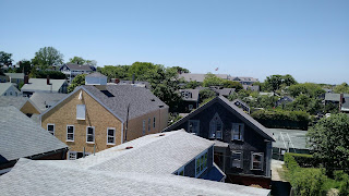
Harbor view from the roof walk of the Museum.

    In the afternoon we toured the Whaling Museum.  Very well done displays on whaling, from tools to scrimshaw, with a special exhibit on the plight of the Nantucket whaler Essex, which recently was made famous recently by the movie Heart of the Sea.  (The author Nat Philbrick lives in Nantucket.) Part of the museum is in the old candle factory, where sperm oil was pressed into oil, with the waxy leftovers made into candles.   We watched a forty minute movie about the island and listened to a docent give us a mini lecture on a typical whaling voyage.  Very interesting museum, we both enjoyed it.  
Sperm whale skeleton and assorted whaling tools.
Oil press.  Sperm oil was placed in burlap bags and stacked under the square blocks, then pressed to filter it.


     Once done with that, we felt we’d seen enough.  We went back to the grocery store for some more fresh produce and returned to the boat for supper.  Tomorrow we hope to get close to the Cape Cod Canal for the final leg of our cruise back to Maine.  
Sunset over Nantucket Harbor
Wednesday & Thursday June 15-16: Martha’s Vineyard
     We left Block Island around seven am.  After three nights our anchor had dug itself in pretty good; it took several buckets of water to dislodge the mud we brought up.  Next stop: Martha’s Vineyard, close to forty nautical miles away.  The current was with us a good portion of the way and we did pretty well with just the jib up.  
Southeast Lighthouse on Block Island

    Last fall we had anchored one night in Menemsha Bight, on the very Western end of the island.  This time we headed for Vineyard Haven.  We don’t have a current guide for New England (ours is Duncan & Ware, vintage 1977) so we relied on the internet to tell us about anchorages there.  The harbor is long and deep; we read the anchorages were just outside the mooring field, which meant outside the breakwater, as the mooring field was so tightly packed it’s a wonder the boats don’t swing into each other.  The ferry channel runs right alongside both anchorage and moorings.  We opted to go into the Lagoon Pond (really, that’s the name of it) which parallels the harbor, which meant requesting an opening from the bascule bridge which separates the two.  There are construction barges and cranes obscuring the bridge opening - they’ve been working on this bridge for well over a year.  The bridge tender kindly opened for us when asked, and Dan navigated the narrow opening into a large pond also dotted with moorings and we found an anchorage among them just off the Western shore.  By the time we got all settled, we opted to just have supper and go ashore in the morning to make a day of it.  He fired up the grill for hamburgers which we enjoyed with homemade sweet potato fries. 
See the bridge?
 See our path?
See how narrow?  Isn't Dan a great captain!

    We decided to rent a moped and give ourselves a full tour of the island.  We’ve never done that before, but it seemed like more fun than renting bicycles and less expensive than renting a car.  We only had to walk a couple of blocks to find a rental company.
     $99 for the moped, they told us.  Our mouths dropped open.  “Really?”  Dan asked.  We turned to go see what rental cars cost and the owner, seeing he was losing us, offered us a slight discount.  Half-day price for a full day’s use, he said.  $79.  Full season rates start this weekend, so we figured this was the best we were going to get.  (We found out later rental cars’ off-season rates are $125/day.)  Dan got a brief lesson on how to operate the vehicle and we set off.  He drove, I clung to him and tried to keep my feet on the little passenger foot-bars.  
Moped selfie

     It wasn’t comfortable to drive or ride, but it got us around the whole island.  We first went West, to Menemsha.  This little town is where they filmed the movie “Jaws.”  The Western section of the island is comprised of tall, brightly colored clay cliffs.  The whole area is owned by natives of the Wampanoag tribe, which has lived on Martha’s Vineyard  for centuries, long before Europeans arrived in the early 1600s.  We had lunch on the top of the cliff where the lighthouse and small interpretive building is, along with the usual food stands and t-shirt boutiques.  
 Gay Head cliffs & light.
Clay cliffs.

     Back on the moped we rode along the Southern shore of the island all the way to Edgartown on the Eastern side, where Martha’s Vineyard faces the small island of Chappaquidick.  We found ourselves on Peases Point Way, one of the main roads in Edgartown, and we stopped at the cemetery there to look up some of Dan’s ancestors.
Peases Point Way.
     In the early 1630s, two Pease brothers emigrated from England, taking up residence first in Salem, MA.  One of them traveled up to Maine and established a family line in the Appleton area.  Dan’s ancestors descend from the other brother, some of whom went to settle on Martha’s Vineyard.  We found many Pease gravestones, some dating back to the 1700s.  A caretaker suggested we go down the road to another, older graveyard to see some of the oldest burial sites on the island.  We did, and enjoyed reading the old style script and seeing dates in the 1600s, but we found no Peases buried in that cemetery.
     Back in Edgartown, we parked the moped and walked to the harbor.  Almost all the houses are cedar shingled and have white picket fences around their yards.  The streets are very narrow and the commercial buildings open right onto the sidewalks.  We treated ourselves to some ice cream and watched the harbor and the people for a bit, then decided it was time to head back to Vineyard Haven.
Edgartown Harbor & Light.  Chappaquidick in the background.

    The moped had other plans.  We got a few blocks from our parking spot and it coughed, sputtered, and stopped running.   After several attempts to call the rental company we finally got through to someone who said she would try to find someone to bring us a new bike.  Dan requested a pickup instead.  “Just come get us.”  He said, and they agreed.  Not ten minutes later the owner himself drove up.  He was in the area with his other business - glass replacement - and seemed unsurprised that the moped wouldn’t run.  He left the moped there on the corner and took Dan and I back to Vineyard Haven.  It was around 5 pm now, and the roads were busy enough that we were grateful not to be navigating them on the scooter.  Mopeds don’t go much over 25mph; it was a bit nerve-wracking to have trucks and buses right on our tail.  Next time, Dan told me, we just get on a tour bus.  

Tuesday, June 14, 2016

Sunday - Tuesday June 12-14: Great Salt Pond, Block Island

     We were awakened before dawn by the fishing boats pulling out of Orient Point Marina.  It was flat calm out there; we thought we’d leave too.  The NOAA forecast called for a gale warning to begin around eleven am.  If we left now, we could be all tucked in at Block Island before anything happened out on the Sound.  
Sunrise over Block Island Sound

     We had a very nice, uneventful crossing from Orient Point over to Block Island.  The tide and current was with us.  The sea was calm until we got beyond Long Island, then it had a large swell running from the South, but it wasn’t anything to be worried about.  It was thirty miles, about four hours to our destination.  As we got nearer to the island, the winds started picking up and a chop was starting to develop.  We timed this right, we thought.
     To our surprise, we saw a steady stream of sailboats heading out the Great Salt Pond Inlet.  Out of the shelter of Block Island, right into the coming weather.  Six, seven, twelve, eighteen boats and counting.  We were flabbergasted.  Already it was starting to get a little rough; we couldn’t imagine the pounding these boats were going to take as they headed across the Sound back to home ports in Connecticut or Rhode Island.  “Really?”  Dan kept saying as we watched them come out and raise sails.  
The boats out and coming out.  See the front building.

     Well, more room for us then.  Block Island is known for its crowded harbor.  We were surprised to find out just how large this Pond truly is, it's hard to imagine it being really crowded.  We’ve read stories about boats vying for the first-come, first-serve town moorings ($45/night, no showers, no laundry, launch service and “landing fee” extra) and ending up on one of the hundreds of ‘private’ moorings for $50 rather than trying to find space in the crowded anchorage with its reputed poor holding ground.  We had no such troubles, but it's early in the season.  There was plenty of space in the anchorage, and more than three-quarters of the moorings available.  As the gale force winds began to whip the Pond into whitecaps, we entertained ourselves watching yet more sail boats leave.  
     NOAA predicted this weather would remain gusty for several more days.  We spent the rest of Sunday snug in our cabin, reading, napping, and cooking.  We had baked trout and fresh asparagus for supper, with hollandaise sauce.  There was even leftovers for Monday morning’s feast of eggs Benedict.
     Monday was spent in quiet puttering.  I baked banana bread.  Dan changed the oil.  Tommie shifted her bed to take best advantage of the sun.  Outside the wind howled, calmed, howled again.  We had thought about going ashore for a walk but the wind thwarted us until late afternoon when it died down enough to make the dinghy ride across the Pond not such a wet adventure.  We had an early supper, launched the dinghy and went ashore.
Ocean Ave, New Shoreham.
     It’s about a fifteen minute walk to town, which is mostly hotels, bars, and t-shirt shops.  Many of them were not yet open for the summer.  This place must be bustling in the summer.  It reminded me a little of Bar Harbor.  Block Island also sports several miles of hiking trails and a historical society building, but the trails weren’t near us and the historical society building doesn’t open until the end of the month.  We visited the little grocery store for a pint of Ben & Jerry’s and sat down on a bench to people watch and share the ice cream before returning to the boat to watch the beautiful sunset.  
Sunset in Great Salt Pond
     Tuesday and we’re still here, now going a little stir crazy.  NOAA still says gusts up to 25 knots, and tomorrow’s forecast sounds a lot nicer, so we’re here for another day.  Dan made himself a large omelet with the last of last night’s sirloin.  (We always eat fancier when we’re at anchor for a few days.)

     More mundane projects - I did laundry, Dan organized the cockpit storage and dug out some supplies we’ll be needing soon.  He also did some minor sewing repairs to the sail cover.  Tommie found it exhausting supervising us and took a long nap.  Another trip to town to hang out in the town library, making use of the free wifi to browse, take care of business, and update the blog.  Ham & beans for supper, but we're stopping at the grocery store to pick out something for the grill for tomorrow.


Saturday, June 11, 2016

Saturday June 11: Back to New York

     Dan gets husband of the year award - this morning he let me sleep in.  He got up at five and I put on my noise canceling headphones.  He weighed anchor, made breakfast, and set off and I slept in till seven-thirty.
     The plan was to get as far as Old Saybrook Harbor and get all tucked in before the forecasted rain and possible thunderstorms spread over Long Island Sound.  The water was glassy and the winds were light, but the horizon was gray all around, and as we traveled we could see the storm clouds darkening.  About mid-morning Dan suggested we head for the tip of Long Island instead of Old Saybrook.  We’d never been to any anchorage on Long Island, and this would be closer to Block Island, where we hope to spend the next couple of nights.  He found a marina on Navionics and called to inquire about a slip.  Yes, they said, they would have room.
     Just before we got to Orient Point - the end of Long Island before Plum Island and Montauk - the rains came.  And the tide turned.  This area was already listed as a “rip tide area”, so we were prepared for a little rough water, and we were very grateful that we only have about thirty minutes of it all before turning into the small and very narrow channel that led to the even narrower entrance of the marina.
Orient Point Light
Plum Island - rumor has it the government tests anthrax here.  Whatever goes on, the whole island is government owned and visitors are prohibited.
     Orient Point is a very small town that sports a state park and this marina and restaurant.  It’s really more of a marina for fishing charters, (i.e., not fancy, and without much in the way of amenities) but they happily accept transient cruisers and the people here are exceptionally friendly.  We spent a little time at the outdoor bar, meeting Willy from across the Sound who had come over with his buddies for an afternoon of drinking, and watched the local fishing charters filet their catch off the sterns of their boats. The bartender handed over keys to the showers and gave us the wifi code.  Bob, the owner, lent us his truck to go to the next town - eight miles away - for a small grocery run.  After our run, we went back to the restaurant for dinner, and the accommodating staff allowed us to order from the smaller lunch menu because we just weren’t hungry enough for the gourmet dinner entrees.  (Although, we did find room for the peanut butter pie, which was as excellent as the rest of the meal.) What this place lacks in yacht club-type ambience, it makes up twofold in character, friendliness, and food.  
The entrance to the marina - about forty feet wide.
Orient Point Marina & Restaurant.  


Thursday-Friday June 9 & 10: To & Thru New York
     We left the Glimmer Glass in time for the first bridge opening - 7:00 am - without mishap.  It was a little windy, but we hugged the Jersey shore for the 26 miles to Sandy Hook point and though we had a following sea, it was a tolerable ride along the coast  
We passed this pair of egrets on our way out of the Glimmer Glass.
Jersey Shore.

     It was a different story when we got around Sandy Hook.  The sea was confused - wind and current driven, with a five foot chop.  Dan adds “sloppy”, but points out that we only dipped the bow once.  The splashes from the waves drove us indoors; later we found the entire boat coated with salt.
     We had been going back and forth about destinations - tossing around Great Kills Harbor on Staten Island, where we’d stayed in the fall, Coney Creek on Coney Island, or Liberty Park right in New York Harbor.  Great Kills Harbor was closest, Coney Creek didn’t seem prudent given the forecast of Westerly winds, and Liberty Park offered the best all around protection but was about two hours away.
     We opted for Great Kills Harbor.  It was a very bumpy and wet ride, and we were very happy to drop the hook amongst the unoccupied moorings off the Great Kills Yacht Club.  Dan turned in for a nap, I busied myself with small chores.  We had baked zucchini for supper.  It was a very relaxing evening, welcome after the stressful passaged from the tip of New Jersey.
     Friday we were up and out of there, again off by seven.  It had calmed down considerably during the night and we were hoping to ride the current and favorable tide through the Verrazano Narrows and right through New York City.  The seas were much more comfortable as we made our way toward the city.

     As we’ve seen before, this is a very busy harbor!   Ships were anchored in a long row from the bridge to the entrance of the Hudson river, ferries were criss-crossing the area, and there was a steady stream of traffic coming and going around Staten Island.  Even the helicopters were already out and about.  We timed it all pretty well - we traveled through the East river at up to nine knots.  We were through Hell’s Gate by ten-thirty, well before the tide was supposed to turn.
Some of the ships steaming out of the Staten Island inlet.
Anchored ships in front of the city.
Leaving the city behind us.


     We hugged the NY shore as we headed into Long Island Sound.  The current was favorable, but the winds were starting to pick up again.  It was calmer along the shore.  Fortunately, when the current started to shift, the winds died out.  We made it to Norwalk CT for our anchorage, finding a pretty little spot in the Sheffield Islands.  It was near dead calm, which was a good thing, because the anchor bounced along a couple of times before settling down.  (We found out in the morning it had never dug in - note to self: this is an anchorage in calm weather only!)  Spaghetti for supper.  The perfect meal after a chilly day; today we brought out the hats, mittens, and long pants.

Wednesday, June 8, 2016

Wednesday June 8: Manisquan Inlet and the Glimmer Glass

     We set off about eight this morning, intending to get all the way through the rest of the New Jersey Intracoastal Waterway.  This doesn't mean we're done with New Jersey - we still have about 25 miles offshore to cover to get to Sandy Hook - but this is as far as we can go inland.
     It's chilly!  For the first time since early December we are wearing sweatshirts and fleece and wondering where our mittens and warm hats are.
     The skies started clouding over about noon, and shortly thereafter the rain and wind drove us indoors.  The waves really started to kick up, but the tides and currents were with us and we wanted to take advantage, so we pressed on.
In shallow water, it doesn't take much for the waves to pile up.
     We made good time, reaching the Pleasant Point Canal about three pm.  By then the rains had moved through and the sun was out, but it was still windy and quite chilly.  I suppose it's time for us to get used to it.  
Pleasant Point canal.
     We selected as our anchorage a place called the Glimmer Glass.  This is a small basin up a small creek just inside the Manisquan Inlet.  We've heard about it from other cruisers: it's a favorite stopover when they travel up or down the coast of New Jersey.  There is one last bridge to go through before the basin, and this was the only one we encountered today that had a schedule.  It opens on the hour and half hour, and we arrived twenty-five minutes early, plenty of time to watch the whole opening operation.  It's a small bridge, lifted by a cable which is hand operated by the bridge tender.
With a strong current and a strong wind, its narrow opening is something of an adventure.  Not for the faint of heart.
Glimmer Glass bridge tender - Dan thought he looked like Vince Wilfork.
We are heading for the bridge.
     Once through the bridge you are in the anchorage basin.  There is almost no water to port, and a row of docks to starboard.  We drove our keel into the mud yet again (New Jersey will be forever known in our memories for going aground) but this time Dan managed to back out.  Undaunted, he continued farther into the basin where we anchored in about four and a half feet of water midway between the shoal and the docks.  Fortunately we are the only boat anchored here tonight!  
     The wind continues to howl.  We are considering turning on the heater!